Monday, December 15, 2025
32 F
Murray
Home Blog Page 32

Press release: Team Kentucky challenges teens to drive safely and win big

FRANKFORT, Ky. (Jan. 14, 2025) – Team Kentucky is calling on all teen drivers to participate in the Safe Teen Driving Challenge and compete for a share of $5,000 in cash prizes in an effort to improve highway safety and reduce crashes. Gov. Andy Beshear today joined transportation officials and partners from AAA Blue Grass, AAA East Central and Cambridge Mobile Telematics to announce the registration start for the challenge.

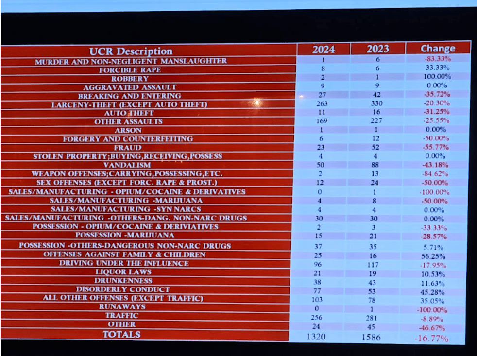
Over the past three years, Kentucky roads have seen more than 47,000 crashes involving teen drivers, resulting in over 13,000 injuries and 210 tragic deaths. The Safe Teen Driving Challenge, managed by the Kentucky Transportation Cabinet (KYTC), aims to change that by encouraging young drivers to build better habits and stay focused behind the wheel.

“As Governor, but also as the dad of two teenagers who I love more than anything, making sure all our drivers are safe on the roadways is a top priority,” said Gov. Beshear. “This new contest is a positive incentive for new drivers to be as safe as possible and to win a cash prize and be named Kentucky’s safest teen driver. We want this generation to be leaders in helping us have fewer crashes and fatalities.”

The challenge rewards the top four drivers with cash prizes, sponsored by AAA Blue Grass and AAA East Central:

  • 1st Place: $2,000
  • 2nd Place: $1,500
  • 3rd Place: $1,000
  • 4th Place: $500

“It’s important for young drivers to be reminded of the dangers of driving distracted. The more good driving behaviors they can develop now, the more likely they are to exhibit safe driving behaviors throughout their lifetimes,” said Lori Weaver Hawkins, public and government affairs manager, AAA Blue Grass. “Driving distracted is just as dangerous as driving impaired. AAA Blue Grass urges teens to stay focused on the roadway, keeping themselves and other road users safe now – and in the future.”  

Winners will be announced in April, and their accomplishments will be celebrated as part of Kentucky’s ongoing efforts to improve road safety.

“The ultimate reward for safe driving is protecting yourself and others on the road,” said KYTC Secretary Jim Gray. “This challenge helps teens build habits that will last a lifetime and aid in our mission to reduce preventable crashes.”

Gov. Andy Beshear, left, and KYTC Secretary Jim Gray (Photo provided)

How to Join

This challenge is open to 16-to-19-year-old drivers with a valid permit or driver’s license and a smartphone. Parental consent is required for drivers under 18. To join, teens simply:

  1. Visit kentuckyhighwaysafety.com/safe-teen-driving-challenge/ to register between Tuesday, Jan. 14, and Friday, Jan. 24, 2025 (cut-off is 11:59 p.m.).
  2. Download the DriveWell Go™ app, create a new account, and enter the contest token code.
  3. Drive safe, track your performance, and compete for the chance to win a prize.

“We’re excited to merge a meaningful challenge, cool tech and cash prizes to encourage teens to be lifelong safe drivers,” said the Office of Highway Safety Executive Director Bill Bell. “Safer highways are a win-win for all Kentuckians and this challenge will help reveal areas of strength and areas of improvement while they are still early in their driving careers.”

How it Works

The app, powered by Cambridge Mobile Telematics (CMT), uses smartphone sensor data to identify risky behaviors like speeding, hard braking, harsh acceleration, cornering and phone use. Teens can track their progress and see how they rank on the app’s leaderboard, updated every two weeks, to provide valuable data to help young drivers become more aware of their habits behind the wheel.

Driving performance will be measured from Jan. 25 to March 31, 2025, giving participants plenty of time to compete for the top spots.

The app uses machine learning to identify driving behaviors from sensor data and transform them into insights. The platform automatically determines if a person is in a vehicle and calculates if they’re the driver or passenger with 97% accuracy.

“Kentucky’s Safe Teen Driving Challenge has the potential to reduce risky driving behaviors like distracted driving — a leading cause of crashes, especially among teens,” said Ryan McMahon, SVP of Strategy at Cambridge Mobile Telematics. “By leveraging advanced technology and making safe driving fun with prizes, we’re equipping young drivers with the tools and awareness to build lifelong safe driving habits.”

For more information and to register, visit https://kentuckyhighwaysafety.com/safe-teen-driving-challenge/

Bierds reports 17% reduction in crime rate

By Laura Ray/For The Sentinel

MURRAY – Murray continues to uphold its reputation as an incredibly safe town with crime rates reaching their lowest point in five years. At the Jan. 9 Murray City Council meeting, Murray Police Chief Samuel Bierds announced a remarkable 16.77% reduction in overall crime from 2023 to 2024.

“Murray has an incredibly low crime rate; however, 2024 was an excellent year,” he said.

In sharing the Murray Police Department’s (MPD) uniform crime reporting (UCR) data, Bierds highlighted the following improvements as part of his annual report to the council. Weapon offenses were down nearly 85% year-over-year, from 13 to two. Murder and non-negligent manslaughter numbers were also down from a total of six cases in 2023 to just one in 2024, an 83% decrease. Fraud cases also dropped by 56%, while forgery and counterfeiting, sexual offenses (not including forcible rape) and the sales/manufacturing of marijuana all dropped by half.

Bierds attributed these successes to the department’s reorganization in 2024, which optimized officer scheduling with 12-hour shifts, allowing officers to have more days off per year and maximizing the number of officers on patrol at one time. As of Jan. 1, the department has embraced technology by transitioning to a digital records system, reducing paper usage by 95% along with cost and waste.

Driving under the influence (DUI) enforcement remains robust, with officers making 86 DUI arrests in 2024. Bierds noted that two officers alone were responsible for 42 of these arrests, with 21 each. Alcohol-related calls – tracked rigorously in 2024 – totaled 1,688, further highlighting the proactive efforts of law enforcement.

Murray Police Department uniform crime reporting showing reduction in crime rates between 2023 and 2024.

Working with the Kentucky Opioid Abatement Advisory Commission, the MPD brought the D.A.R.E. (Drug Abuse Resistance Education) program to fifth graders at Murray Middle School in 2024. This year’s plans include training an additional officer and expanding the program to more schools. 

Council members raised questions about response times and personnel retention. Bierds noted that retention remains a concern with the department below its authorized staffing level, which he attributed partly to funding and diminished interest in the profession. Bierds said the department “probably could” track response time, although calls can be “stacked” sometimes, based on priority.

In conclusion, Bierds expressed gratitude to the council and the mayor for their “commitment and support legislatively and financially.”

The Murray Fire Department (MFD) also presented encouraging updates. Fire Chief Eric Pologruto highlighted advancements, including an improved Insurance Services Office (ISO) rating from class 3 to class 2, thanks to enhanced training programs he attributed to Assistant Fire Chief Eric Phelps.

The department will soon receive a $2 million ladder truck, funded primarily through grants and state assistance, with a delivery expected in June. Both the mayor and fire chief stressed the importance of Murray having a ladder truck to serve tall buildings, such as dorms, if necessary. Pologruto also mentioned the fire engine company truck that was ordered over two years ago is scheduled to arrive at the end of this month.

When council member Terry Strieter asked if MFD had an adequate number of personnel right now, Pologruto noted challenges in staffing for large-scale fires. He also mentioned the eventual need for a third station to accommodate the city’s western expansion.

In other business, a declaration of surplus property was approved, with proceeds earmarked for the police department. Also, the council approved several measures during the meeting. The first resolution of the year was approved to apply for up to $250,000 in Government  Resources Accelerating Needed Transformation (GRANT) Program funds for a welcome center at Central Park.

Council members were appointed to committees, including the Public Safety Committee chaired by Wesley Bolin and the Park Committee chaired by Johnny Bohannon. City officials were also appointed to boards and commissions: Community Theatre (Jeremy Bell), Electric Plant Board (Danny Hudspeth), Human Rights Commission (Linda Cherry), and Weaks Community Center (Alice Rouse). 

As crime rates decline and public safety departments expand their capabilities, the City of Murray is poised for a promising year ahead. The next council meeting is scheduled for Feb. 13 at 6 p.m. at City Hall. Council meetings are also available to watch live on Murray Electric channel 10 and Spectrum channel 381.

MISD moves forward with land acquisition for new elementary school

MURRAY – The Murray Board of Education announced plans to build a new elementary school on a parcel of land near the intersection of Doran and Wiswell roads at its meeting last night. Superintendent Coy Samons said that the new facility will house kindergarten through fourth grade and boast a capacity of 750 students.

Board attorney William “Chip” Adams, III, made the announcement, noting that the district has been identifying and evaluating potential locations for the new school, including looking at properties already owned by the district.

“Within the next week,” Adams said, “the Murray Independent School District Board of Education will be submitting a request for approval from the Kentucky Department of Education to acquire a certain parcel of real property – 15.118 acres – located within the school district for the purposes of the construction of an elementary school. The property is generally located off of Doran and Wiswell roads.”

The sidewalk on Doran Road, constructed years ago, ends in front of the subject property. (JESSICA PAINE/The Murray Sentinel)

Adams explained that a school district cannot simply acquire real property; they must go through an exhaustive process that is overseen by the Kentucky Department of Education.

“The process, with respect to this parcel of property, has been in the works since last summer,” Adams said. “(A) lot of things that had to be done. At this point, we can’t go into a lot more details because everything is very preliminary; however, there is a parcel that has been identified and it is of a size that is sufficient to construct an elementary school.

“We hope to have a lot more information for you in the months ahead as we negotiate the approval process with the Kentucky Department of Education but go ahead and put it on the forefront – a new elementary school is, hopefully, on the way.”

Board attorney William “Chip” Adams, III, speaks during Thursday’s Murray Board of Education meeting. (JESSICA PAINE/The Murray Sentinel)

“It’s an exciting time to be in the Murray Independent School District,” Samons added before the crowd erupted in in applause.  

“We’ve been looking for more than four years,” Board Chair Richard Crouch added, “and we think we’ve found the parcel that’s going to meet everyone’s criteria and look forward to going forward with that process.”

Crouch commended Adams and Samons for the many hours they have put into the project over the years. In particular, he thanked board member Adam Seiber, who has extensive experience in the real estate industry, for playing an “instrumental” role in the process over the last six to eight months.

The plan to build a new elementary school was announced in December 2023 as part of the district’s long-range facilities plan. After the new school is built, the current elementary school building will be repurposed to house Murray Preschool Head Start, the central office and the maintenance shop.

Following that meeting, Assistant Superintendent of Instruction and Human Resources Whitney York clarified that only some preschool classrooms will be moved. MISD operates six preschool classrooms that are operated with a blend of state preschool funds and federal Head Start funds.

The plan would be to move some of the six preschool classrooms to the current elementary school building after the new school is built; however, which classrooms and how many will be decided in the future. Early Head Start, which is a completely federally-funded Murray Head Start program for children under three years old and is currently located in Murray State University’s Alexander Hall, would not be impacted.

Press release: KYTC updates road conditions

We will continue to update this page as new information is released. Check back here throughout the day.

Crews focus on priority routes (10 a.m. Update)

PADUCAH, Ky. (Jan. 10, 2025) – Kentucky Transportation Cabinet (KYTC) District 1 crews are plowing and treating state highways across all of the district’s 12 counties.

Pre-treating earlier this week helped to give crews a head start on their response efforts. Many crews have been able to make good progress on the “A” Snow Priority Routes and have transitioned to their “B” and “C” routes.

“A” Snow Priority Routes include interstates, parkways, U.S. highways, and some other 4-lane routes.

“B” and “C” Snow Priority Routes are connector and rural secondary highways.

For a complete list of Snow & Ice Priority Routes, please go to:

https://transportation.ky.gov/Maintenance/Pages/Snow-and-Ice-Maps.aspx

Motorists who venture out today should slow down and use appropriate caution. The National Weather Service anticipated the heaviest snowfall would be between 9 a.m. and 3 p.m., and moving out of the District 1 counties around 7 p.m.

For the latest information, visit the National Weather Service Paducah page at https://www.facebook.com/NWSPaducah.


All crews reporting for duty, travel conditions vary county-by-county (6:45 a.m. Update)

PADUCAH, Ky. (Jan. 10, 2025) All Kentucky Transportation Cabinet (KYTC) District 1 crews have reported for duty on Friday morning. Snow is falling in every county, although travel conditions vary.

Crews reported this morning in staggered start times based on forecasted snow arrival times and will work in shifts throughout the winter weather event. 

Trucks are patrolling state highways, observing conditions, and treating as needed. Crews are focusing first on the treatment of interstates, major highways, bridges and overpasses.

As snow accumulation continues to increase this morning, there is a potential for roadways to become hazardous quickly. State highway engineers are urging motorists to use caution and avoid unnecessary travel. Even treated and plowed pavement could be slick.

Maintain a safe distance from snowplows and other heavy highway equipment and do not pass snowplows on the shoulder.

KYTC District 1 has about 87 snow plows, five tow-plows, and several contract plows to cover 2,852 miles of highway in Kentucky’s 12 westernmost counties. 

As a reminder, the U.S. 45 Ohio River “Brookport” Bridge in Paducah is closed until further notice due to icing.  Motorists should detour via the Interstate 24 Ohio River Bridge. KYTC District 1 will provide a timely update when it reopens.

Motorists are advised to monitor the local forecast via area news media outlets or on the National Weather Service Paducah page at https://www.facebook.com/NWSPaducah.

Press release: Affordable Housing Program awards $750,000 for Calloway County project

CINCINNATI (January 9, 2025) – Federal Home Loan Bank of Cincinnati President and CEO Andrew S. Howell announced the recipients of 56 Affordable Housing Program (AHP) grants totaling more than $49.5 million—marking FHLB Cincinnati’s largest grant announcement in AHP history. Awarded to 24 member financial institutions, grant funds will be used to help create 2,743 units of affordable housing benefiting residents throughout Kentucky, Ohio, Tennessee and beyond.

“Our members and the affordable housing organizations they support are facing prolonged challenges in developing and rehabilitating affordable housing throughout our region,” said Andy Howell, FHLB Cincinnati, President & CEO. “While the current housing crisis will require multi-faceted solutions from funding sources across the country, we are proud to do our part through our largest ever announcement of Affordable Housing Program grants. Since the program’s inception, more than $686 million has been disbursed through our members to benefit local nonprofit organizations to help build and rehabilitate housing in the communities we serve.”

FHLB Cincinnati allocates 10 percent of its net income annually to the AHP, which makes housing more affordable for households at or below 80 percent of the area median income. Subsidy is awarded to members through an annual AHP competitive offering and through the Welcome Home Program’s down payment assistance grants. This 10 percent allocation was enhanced in 2024 by an additional $40.5 million in voluntary funds which went in part to fund the AHP through the down payment assistance program. Additional voluntary funds have supported home rehabilitation for low-income homeowners, disaster reconstruction and first-generation home ownership.

Since the first awards in 1990, the FHLB has disbursed more than $686 million toward nearly 93,000 units of affordable housing through the AHP and Welcome Home Program. These programs have enabled thousands of families to access decent, affordable housing.

For more information on specific awards and details of AHP, visit the FHLB Cincinnati website at www.fhlbcin.com.

Calloway County project

RiverHills Bank, Heritage Bank and Spire Development received a $750,000 Affordable Housing Program (AHP) grant from the Federal Home Loan Bank of Cincinnati (FHLB Cincinnati) for a project located in Murray.

Titled Bee Creek Crossing, the project involves the new construction of 60 units in Murray, Ky., for very low- to moderate-income households, all of whom will have special needs. The $15,767,733 project will be financed with equity from the sale of tax credits, a permanent loan by the banks, deferred developer fee, cash contributions from Spire and a $750,000 AHP grant. The project will provide housing in combination with a program offering services to assist residents to move toward better economic opportunities. 

This grant is one of 56 AHP grants awarded by FHLB Cincinnati, totaling more than $49.5 million. Awarded to 24 FHLB Cincinnati member financial institutions, grant funds will be used to help create 2,743 units of affordable housing benefiting residents throughout Kentucky, Ohio, Tennessee and beyond.


About the FHLB

The FHLB is a AA+ rated wholesale cooperative bank owned by 607 member financial institutions, including commercial banks, thrifts, credit unions, insurance companies and community development financial institutions in Kentucky, Ohio and Tennessee. The FHLB provides members access to products and services (primarily Advances, which are a readily available, low-cost source of funds, purchases of certain mortgage loans from members, and issuance of Letters of Credit to members) and a competitive return through quarterly dividends on their capital investment in the FHLB. The FHLB funds these products and services by raising private-sector capital from member-stockholders and, with the other Federal Home Loan Banks (FHLBanks) in the FHLBank System, issuing high-quality debt in the global capital markets. The FHLB also funds community investment programs that help its members create affordable housing and promote community economic development.

Press release: The Murray Bank names Bona CFO

MURRAY – The Board of Directors of The Murray Bank, a cornerstone in our community for a quarter of a century, proudly announces a significant leadership promotion as part of a long-term succession planning initiative. Board Chairman, Ronnie Gibson stated Leah Bona will assume the role of Chief Financial Officer. Bona will fill the role left vacant by former CFO, Marla Geib Hendrick, who retired at the end of 2024. Bona’s transition into this role took effect on January 1, 2025.

“It’s a privilege to take on the role of Chief Financial Officer at The Murray Bank, and I’m truly grateful for the confidence the Board of Directors has shown in me,” said Bona. “Marla Geib Hendrick’s training has been instrumental in preparing me for this opportunity, and I’m excited to continue building on the foundation she helped create. I look forward to partnering with our talented team to reach new milestones together.”

Bona came to The Murray Bank a year ago from Alexander Thompson Arnold PLLC (ATA) with over 15 years of experience in public accounting, as well as over 10 years of experience in private accounting as a controller and CFO. Her responsibilities at ATA included tax and financial planning, preparation of corporate, business and individual tax returns, governmental and nonprofit auditing and an extensive range of accounting services.

Bona graduated from Murray State University with a Bachelor of Science in accounting. She received her Master of Business Administration with an accounting emphasis from Murray State University in 1996. Bona is a member of the American Institute of Certified Public Accountants (AICPA) and the Kentucky Society of CPAs.

“Leah is a driven leader and strategic thinker who believes in our core values,” said Tony Ryan, President & CEO at The Murray Bank. “This, along with her education and accounting experience position her well to move into the CFO role. I’m confident Leah is up to the task and look forward to working with her in her new capacity.”

Bona can be reached at the Main Office of The Murray Bank, 405 South 12th Street, or by calling (270) 753-5626

Press release: MPD names Clere assistant police chief

Staff Report

MURRAY – The Murray Police Department announced the recent promotions of three officers who, according to the release, continue to demonstrate dedication and commitment to the community.

Justin Swope was promoted to the rank of sergeant, Michael Weatherford to the rank of captain and Angel Clere to the rank of major. Clere was also appointed as the new assistant chief of police, filling the opening left when Major John Cooper retired at the end of last year.

In a separate release announcing his retirement, the MPD commended Cooper for exemplifying unwavering dedication, integrity and service to the community, adding that his leadership and commitment to safety will have a lasting impact on the department for years to come.

“Major Cooper, thank you for your service and for leaving a legacy of excellence,” the release said. “Your hard work has made a difference, and you will be missed by all who have had the privilege to work alongside you.  We wish you all the best in your well-deserved retirement. ‘Best Job I Ever Had.’”

Assistant Police Chief Major John Cooper, left, and Police Chief Sam Bierds (Photo provided)

Weekly Public Meeting Schedule (Jan. 6-10) UPDATED

UPDATE (Jan. 9): Scroll to Friday for special called meeting information.

Monday, Jan. 6:

  • The Calloway County Fire Protection District Board of Trustees will meet at 6 p.m. at Firehouse 1, 101 E Sycamore.

Tuesday, Jan. 7:

None


Wednesday, Jan. 8:

  • The Murray-Calloway County Hospital Board of Trustees Quality Committee will meet at noon in the hospital’s Garrison Boardroom and via Zoom (call 270-762-1102 for Zoom connection details). See agenda below.
  • The Murray-Calloway County Hospital Board of Trustees will host its annual city-county meeting at 1:30 p.m. via Zoom only. See notice below for connection details.

Thursday, Jan. 9:

  • The Murray School Board will meet at 6 p.m. in the Carter Administration Building. See agenda below.

Note: A public hearing regarding the 2024 Nutrition and Physical Activity Report Card will be held at 5:45 p.m. A special-called meeting of the Murray Independent School District Finance Corporation will immediately follow the board meeting.

  • The Murray City Council will meet at 6 p.m. at City Hall.

Friday, Jan. 10:

  • The Murray State University Board of Regents will hold a special called meeting at 3:30 p.m. in Wells Hall, Room 118. See agenda.

Press release: Beshear declares state of emergency ahead of storm, activates price gouging laws

FRANKFORT, Ky. (Jan. 4, 2025) – Today, Gov. Andy Beshear declared a state of emergency ahead of a severe winter storm system set to affect much of the commonwealth. The storm is expected to begin Sunday, Jan. 5, and bring snow, freezing rain, ice and arctic temperatures.

The storm could cause widespread power outages, and freezing temperatures will persist throughout the week, making roads treacherous.


Related coverage from The Sentinel: Holland tracks upcoming winter storm


The Governor is taking action by activating units of the Kentucky National Guard to stand ready to respond. State transportation workers are also preparing to act, and local emergency management officials are working to open needed warming centers. The Governor also activated the state’s emergency operations center and implemented the state’s price gouging laws to protect Kentuckians from overpriced goods and services as they clean up and recover from the storm. Consumers should report price gouging to the Office of the Attorney General.

“This winter storm will likely cause significant disruption and dangerous conditions on our roads and could cause significant power outages – just 24 hours before it gets dangerously cold,” Gov. Beshear said. “We care about every Kentucky family and those traveling through our great state, and we want to make sure everyone has the information and resources needed to stay safe.”

The Governor’s executive order directs the Kentucky Division of Emergency Management to coordinate the state’s response across agencies and private relief organizations.

“The state emergency operations center will be activated tonight at midnight and will stay open for the duration of this event,” Kentucky Emergency Management Director Eric Gibson said. “During that time, we’ll have state agencies from across the commonwealth and the representatives there to coordinate their response.”

Director Gibson also urged Kentuckians to be careful if using a generator. Many households run generators during a power outage, and homeowners should take extra precautions to avoid injury. Gasoline- or diesel fuel-powered generators can produce potentially deadly levels of carbon monoxide and should be operated only in well-ventilated, covered, unheated areas – never inside.

Team Kentucky state highway crews have been monitoring weather conditions, prepping equipment to clear snow and debris, and began some pretreating activities as early as Thursday in parts of the state where conditions allowed. Kentuckians are urged to avoid nonessential travel and to plan extra time for their Monday morning commute if they must travel.

“This winter storm is serious, and the extreme cold we’re facing days afterward will make travel more hazardous and impact the speed of even our best road treatments, especially after dark,” said Kentucky Transportation Cabinet (KYTC) Secretary Jim Gray. “Our focus is to keep priority routes open, like interstates and parkways, before moving to other routes. Our force of state and contracted crews are ready and will be active. Motorists should exercise caution if they must be on the roads by driving distraction-free and slowing down.”

As part of the emergency declaration, Secretary Gray issued an official order aimed at maintaining supplies of propane, fuel, oil and kerosene. Among the provisions, the order temporarily suspends certain drive time and weigh station restrictions on motor carriers engaged in transporting emergency relief supplies or involved in power restoration activities.

KYTC offers the following tips for drivers:

  • Give plows plenty of space on the roads, and increase your distance between you and the car ahead of you.
  • Avoid unessential travel. If returning to Kentucky from a holiday trip, travel today or make alternate plans.
  • If travel can’t be avoided, make sure you have an emergency car kit to keep yourself and other passengers safe for long hours.
  • Remember, roads often aren’t clear until after a storm passes, and bridges/overpasses freeze faster than roads.
  • Drive alert and slow down.
  • Treat dark traffic signals as a four-way stop.
  • Do not touch or drive over downed power lines.

Drivers are urged to check traffic conditions before traveling at GoKy.ky.gov.

For additional preparedness tips, visit kyem.ky.gov.

Holland tracks upcoming winter storm (UPDATED)

Editor’s note: This story was updated at noon on Saturday, Jan. 4. We will continue to update as needed throughout the day.

By Justin Holland

A powerful storm system is expected Sunday and Monday. Remember, this is an evolving storm system so some changes to the forecast are still possible. The track of the low pressure 30-40 miles north or south will make a world of difference in what your location sees.

Calloway County is now under a winter weather advisory from 2 am Sunday through 2 pm Monday. Confidence continues to grow that the Ohio Valley region will see travel impacts from a powerful winter storm that will affect parts of the region Sunday through Monday. The latest guidance is coming in a little colder than previous runs.The overall trend has been towards a surface low that will develop over the southern Rocky Mountains and pass near the Lower Ohio River and Upper Tennessee River Valleys.

Summary slide for Saturday’s 12 p.m. update. (Image courtesy of Murray/Calloway County Weather)

The devil is always in the details with these types of events. A degree or two difference 2000 ft above the ground will have profound impacts on precipitation types and associated impacts.

Precipitation zones. (Image courtesy of Murray/Calloway County Weather)

The path of the surface low implies that there will be a warm nose layer of above-freezing air present during the heaviest precipitation Sunday afternoon for Calloway County. Overall, there looks to be a gradient of increasing impacts as you travel from south to north. Since this system will be laden with moisture from the Gulf of Mexico, whatever precipitation type a location gets, they will get a lot of it. Overall liquid QPF remains quite high, around 1.25-1.75″ in most areas.

As things stand now, we can finally make a “final prediction” of precipitation types and potential impacts for Calloway County.

It appears that an initial burst of sleet or freezing rain is possible early on Sunday morning that could cause some slick travel on roads and other surfaces. Travel will not be recommended before 12 pm Sunday. As the day progresses temps should slowly warm above freezing changing the precipitation over to mainly liquid rain during the afternoon hours Sunday and Sunday evening which will melt any ice from the roads and surfaces.

Preciptation start times. (Image courtesy of Murray/Calloway County Weather)

However, as colder air filters into the region, the event will likely end as a light wintry mix or light snow late Sunday night or Monday morning. A light snow accumulation is likely with more travel impacts and slick roads likely for Monday morning. Overall, travel impacts here are possible at the beginning and ending of the event, but may be more spotty and intermittent given the potential for several hours of plain rain.

Precipitation end times. (Image courtesy of Murray/Calloway County Weather)

Areas to the north of us will stand the best opportunity to see major ice and snow accumulations from this system. Anyone traveling north should be prepared for major road issues and even power outages.

The bottom line for Calloway County:

  • Slick and icy conditions are expected from 2 am Sunday through 12 pm Sunday.
  • Plain liquid rain with better road conditions are expected Sunday from 12 pm to 12 am Monday.
  • Light snow and light wintry mix likely Monday morning from 12 am to 9 am with minor accumulations along with more slick travel.
  • Higher accumulations and more impacts will be north of Murray in northern Calloway County and smaller accumulations south of Murray in southern Calloway County.
  • All areas will see some impacts though so use caution.
  • Keep up to date on the latest forecast updates and consider changing travel plans for Sunday-Monday if you can.

After this storm departs, a wave of very cold Arctic air will impact the region for much of the upcoming week. Right now, temperatures look to be about 10-20 degrees below normal, which would yield high temperatures in the 20s and lows in the single digits or teens. Subzero wind chill values are also a possibility. This wave of cold air looks to persist for several days, so groups that work with vulnerable populations should prepare for cold weather impacts to these groups. While overall, it looks pretty dry, all it would take would be a weak clipper system with 0.1-0.2″ of QPF to cause impactful snow events to occur. That will be something to watch after we get past the early week winter storm.


Justin Holland is the Official Weather Observer of Calloway County for the Paducah National Weather Service and the creator of the Facebook page Murray/Calloway County Weather, a hyper-local weather page followed by more than 17,000 people, and the website murrayweather.com. Holland also offers a severe weather alert texting service for $1/month. To sign up, email him at murraycallowaycountyweather17@yahoo.com.


UPDATE: 5:40 p.m. (1/5/24)

Calloway County remains under a winter weather advisory until 12 pm Monday.

The strong low pressure will move to our east tonight and we will be on the back side which will usher in much colder temperatures. A flash freeze is likely which is any lingering water puddles freezing quickly on area roads and surfaces.

Wrap around moisture associated with a deformation band on the backside of a surface low pressure will cause the atmosphere to quickly saturate again. This will support a period of light snowfall or light freezing drizzle late tonight into Monday morning. Any snow that does fall will be able to accumulate on all surfaces as the cold conveyor belt causes temps to plummet into the 20’s. A light dusting of snow is possible for some areas. Not all areas will see this light snow and freezing drizzle.

Be prepared for slippery roads. Slow down and use caution while driving. If you are going outside, watch your first few steps taken on stairs, sidewalks, and driveways. These surfaces could be icy and slippery, increasing your risk of a fall and injury.

After snow comes to an end Monday morning, an arctic cold blasts remains on track to impact us through the week with temps remaining mainly below freezing through at least Thursday. The most impactful morning looks to be Wednesday with lows in the teens and single digits that translates to wind chill values between -5 to 5 degrees.


UPDATE: 4:30 p.m. (1/3/25)

Here is the snow accumulation probabilities. Start times will be between 12-3 am Sunday for Calloway County. Ending times will be 5-9 am Monday. We will NOT have wintry precipitation for this entire duration.

A changeover to plain rain is expected for most of the Sunday pm hours. Travel problems and slick surfaces will be likely during Sunday and Monday mornings. The northern part of the county will see the most ice and most impacts. The southern part of the county will see the least ice and least impacts. Places along the Ohio River will have a substantial ice storm with tree damage and power outages. I am not expecting that in Calloway County at this time. The system will end with some light snow on Monday morning.

Remember, this is an evolving system so additional changes are possible. Monitor future updates.


UPDATE: 4 p.m. (1/3/25)

Here are the estimated start and end times for the wintry precipitation. Start times will be between 12-3 am Sunday for Calloway County. Ending times will be 5-9 am Monday. We will NOT have wintry precipitation for this entire duration. A changeover to plain rain is expected for most of the Sunday pm hours.

Travel problems and slick surfaces will be likely during Sunday and Monday mornings. The northern part of the county will see the most ice and most impacts. The southern part of the county will see the least ice and least impacts. Places along the Ohio River will have a substantial ice storm with tree damage and power outages. I am not expecting that in Calloway County at this time.

The system will end with some light snow on Monday morning. Remember, this is an evolving system so additional changes are possible. Monitor future updates.


UPDATE: 12 p.m. (1/3/25)

A powerful storm system is expected Sunday! Remember, this is an evolving storm system so some changes to the forecast are still possible. The track of the low pressure 30-40 miles north or south will make a world of difference in what your location sees.

Confidence continues to grow that parts of the Ohio Valley region will see travel impacts from a powerful winter storm that will affect parts of the region Sunday through Monday. The latest guidance is coming in a little colder than previous runs. The overall trend has been towards a surface low that will develop over the southern Rocky Mountains and pass near the Lower Ohio River and Upper Tennessee River Valleys.

The devil is always in the details with these types of events. A degree or two difference 2000 ft above the ground will have profound impacts on precipitation types and associated impacts.

The path of the surface low implies that there will be a warm nose layer of above-freezing air present during the heaviest precipitation Sunday afternoon for Calloway County. Overall, there looks to be a gradient of increasing impacts as you travel from south to north. Since this system will be laden with moisture from the Gulf of Mexico, whatever precipitation type a location gets, they will get a lot of it. Overall liquid QPF remains quite high, around 1.25-1.75″ in most areas.

As things stand now, we can make a “first guess” of precipitation types and potential impacts for Calloway County.

It appears that an initial burst of sleet or freezing rain is possible early on Sunday morning that could cause some slick travel on roads and other surfaces. As the day progresses temps should slowly warm above freezing changing the precipitation over to mainly liquid rain during the afternoon hours Sunday and Sunday night. However, as colder air filters into the region, the event will likely end as a light wintry mix or light snow late Sunday night or Monday morning. Overall, travel impacts here are possible at the beginning and ending of the event, but may be more spotty and intermittent given the potential for several hours of plain rain.

Areas to the north of the Ohio River will stand the best opportunity to see major ice and snow accumulations from this system. Anyone traveling north should be prepared for major road issues and even power outages.

It is not out of the realm of possibility to have a stray strong to severe storm Sunday afternoon since we should be south of the warm front.

The bottom line for the entire region: This forecast will likely shift and change over the next few days before things come in better focus by the weekend. Keep up to date on the latest forecast updates, and consider changing travel plans for Sunday-Monday if you can.

After this storm departs, a wave of very cold Arctic air will impact the region for much of the upcoming week. Right now, temperatures look to be about 10-20 degrees below normal, which would yield high temperatures in the 20s and lows in the single digits or teens. Subzero wind chill values are also a possibility. This wave of cold air looks to persist for several days, so groups that work with vulnerable populations should prepare for cold weather impacts to these groups. While overall, it looks pretty dry, all it would take would be a weak clipper system with 0.1-0.2″ of QPF to cause impactful snow events to occur. That will be something to watch after we get past the early week winter storm.

Stay with Murray/Calloway County Weather for all your local weather coverage!


UPDATE: 7:51 p.m. (1/2/25)

Highest risk for significant wintry precipitation is well north of Calloway County. Our time frame for concern for minor issues will be 1-10 am Sunday and again 1-10 am Monday.


UPDATE: 2:26 p.m. (1/2/25)

Winter storm watches being issued to our north for Sunday. This is as expected as the heavier ice accumulation will be north of Calloway County although we could still have some minor issues early Sunday morning and early Monday morning.


Original story (published Jan. 2)

MURRAY – Confidence continues to grow that parts of the Ohio Valley region will see travel impacts from a powerful winter storm that will affect parts of the region Sunday through Monday. The latest guidance has tipped its hand a bit on what the region will see.

The overall trend has been towards a surface low that will develop over the southern Rocky Mountains and pass near the Lower Ohio River and Upper Tennessee River Valleys. This has resulted in thermal profiles less supportive of an all-snow or even an all-ice event and more supportive of a mainly rain event.

The devil is always in the details with these types of events. A degree or two difference 2000 ft above the ground will have profound impacts on precipitation types and associated impacts.

Low pressure will track overhead which is mainly conducive for liquid rain. (Image courtesy of Murray/Calloway County Weather)

The path of the surface low implies that there will be a warm nose layer of above-freezing air present during the heaviest precipitation Sunday afternoon and Sunday night. Overall, there looks to be a gradient of increasing impacts as you travel from south to north. Since this system will be laden with moisture from the Gulf of Mexico, whatever precipitation type a location gets, they will get a lot of it. Overall liquid QPF (Quantitative Precipitation Forecast) remains quite high, around 1.25-1.75″ in most areas.

You can see the warm nudge of air locally. (Image courtesy of Murray/Calloway County Weather)

As things stand now, we can make a “first guess” of precipitation types and potential impacts for Calloway County.

It appears that after an initial burst of sleet or freezing rain on Sunday morning, a change over to mainly liquid rain will happen during the afternoon hours Sunday and Sunday night. However, as colder air filters into the region, the event will likely end as a light wintry mix or light snow late Sunday night or Monday morning. Overall, travel impacts here are possible at the beginning and ending of the event but may be more spotty and intermittent given the potential for several hours of plain rain.

Areas to the north of the Ohio River will stand the best opportunity to see major ice and snow accumulations from this system. Anyone traveling north should be prepared for major road issues and even power outages.

The bottom line for the entire region: This forecast will likely shift and change over the next few days before things come in better focus by the weekend. Keep up to date on the latest forecast updates and consider changing travel plans for Sunday-Monday if you can.

Preliminary ice forecasts which is mainly north of us. (Image courtesy of Murray/Calloway County Weather)

After this storm departs, a wave of very cold Arctic air will impact the region for much of the upcoming week. Right now, temperatures look to be about 10-20 degrees below normal, which would yield high temperatures in the 20s and lows in the single digits or teens. Subzero wind chill values are also a possibility. This wave of cold air looks to persist for several days, so groups that work with vulnerable populations should prepare for cold weather impacts to these groups. While overall, it looks pretty dry, all it would take would be a weak clipper system with 0.1-0.2″ of QPF to cause impactful snow events to occur. That will be something to watch after we get past the early week winter storm.

Stay with Murray/Calloway County Weather for all your local weather coverage!

Scroll down for updates.

Justin Holland is the Official Weather Observer of Calloway County for the Paducah National Weather Service and the creator of the Facebook page Murray/Calloway County Weather, a hyper-local weather page followed by more than 17,000 people, and the website murrayweather.com. Holland also offers a severe weather alert texting service for $1/month. To sign up, email him at murraycallowaycountyweather17@yahoo.com.

RELATED COVERAGE:

Verified by MonsterInsights