


Editor’s note: This story was updated at noon on Saturday, Jan. 4. We will continue to update as needed throughout the day.
By Justin Holland
A powerful storm system is expected Sunday and Monday. Remember, this is an evolving storm system so some changes to the forecast are still possible. The track of the low pressure 30-40 miles north or south will make a world of difference in what your location sees.
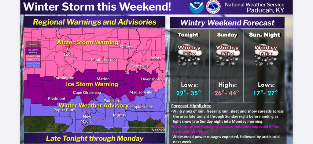
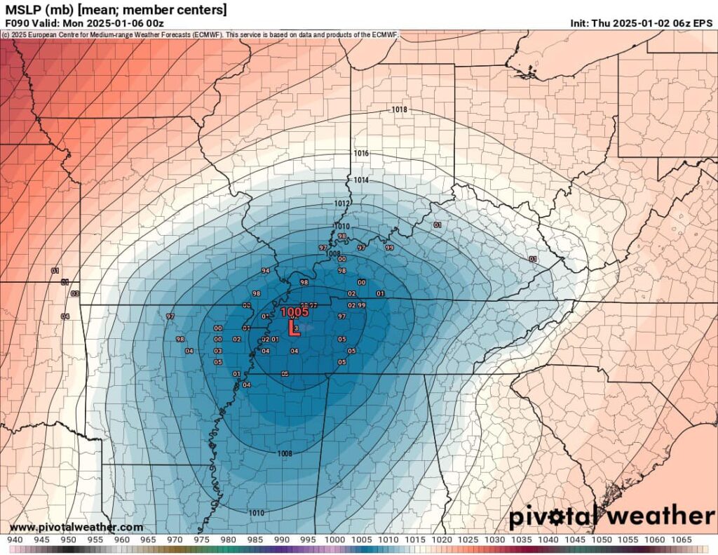
Calloway County is now under a winter weather advisory from 2 am Sunday through 2 pm Monday. Confidence continues to grow that the Ohio Valley region will see travel impacts from a powerful winter storm that will affect parts of the region Sunday through Monday. The latest guidance is coming in a little colder than previous runs.The overall trend has been towards a surface low that will develop over the southern Rocky Mountains and pass near the Lower Ohio River and Upper Tennessee River Valleys.
The devil is always in the details with these types of events. A degree or two difference 2000 ft above the ground will have profound impacts on precipitation types and associated impacts.
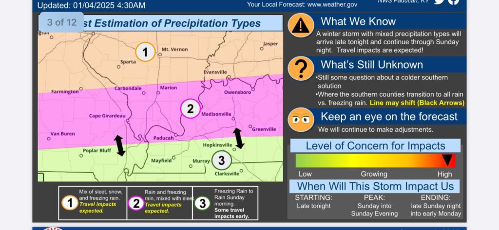
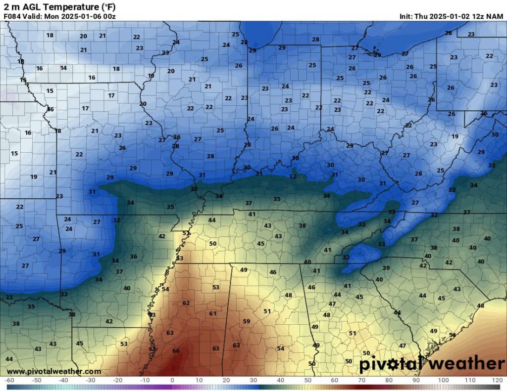
The path of the surface low implies that there will be a warm nose layer of above-freezing air present during the heaviest precipitation Sunday afternoon for Calloway County. Overall, there looks to be a gradient of increasing impacts as you travel from south to north. Since this system will be laden with moisture from the Gulf of Mexico, whatever precipitation type a location gets, they will get a lot of it. Overall liquid QPF remains quite high, around 1.25-1.75″ in most areas.
As things stand now, we can finally make a “final prediction” of precipitation types and potential impacts for Calloway County.
It appears that an initial burst of sleet or freezing rain is possible early on Sunday morning that could cause some slick travel on roads and other surfaces. Travel will not be recommended before 12 pm Sunday. As the day progresses temps should slowly warm above freezing changing the precipitation over to mainly liquid rain during the afternoon hours Sunday and Sunday evening which will melt any ice from the roads and surfaces.
However, as colder air filters into the region, the event will likely end as a light wintry mix or light snow late Sunday night or Monday morning. A light snow accumulation is likely with more travel impacts and slick roads likely for Monday morning. Overall, travel impacts here are possible at the beginning and ending of the event, but may be more spotty and intermittent given the potential for several hours of plain rain.
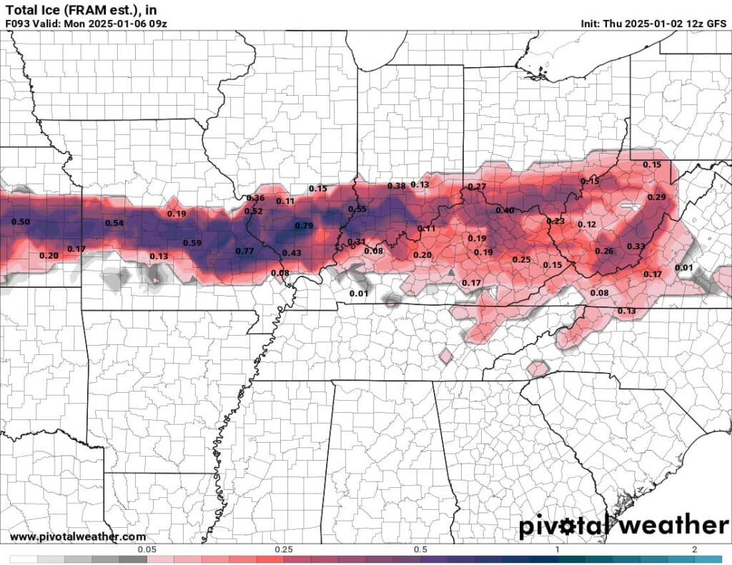
Areas to the north of us will stand the best opportunity to see major ice and snow accumulations from this system. Anyone traveling north should be prepared for major road issues and even power outages.
The bottom line for Calloway County:
- Slick and icy conditions are expected from 2 am Sunday through 12 pm Sunday.
- Plain liquid rain with better road conditions are expected Sunday from 12 pm to 12 am Monday.
- Light snow and light wintry mix likely Monday morning from 12 am to 9 am with minor accumulations along with more slick travel.
- Higher accumulations and more impacts will be north of Murray in northern Calloway County and smaller accumulations south of Murray in southern Calloway County.
- All areas will see some impacts though so use caution.
- Keep up to date on the latest forecast updates and consider changing travel plans for Sunday-Monday if you can.
After this storm departs, a wave of very cold Arctic air will impact the region for much of the upcoming week. Right now, temperatures look to be about 10-20 degrees below normal, which would yield high temperatures in the 20s and lows in the single digits or teens. Subzero wind chill values are also a possibility. This wave of cold air looks to persist for several days, so groups that work with vulnerable populations should prepare for cold weather impacts to these groups. While overall, it looks pretty dry, all it would take would be a weak clipper system with 0.1-0.2″ of QPF to cause impactful snow events to occur. That will be something to watch after we get past the early week winter storm.

Justin Holland is the Official Weather Observer of Calloway County for the Paducah National Weather Service and the creator of the Facebook page Murray/Calloway County Weather, a hyper-local weather page followed by more than 17,000 people, and the website murrayweather.com. Holland also offers a severe weather alert texting service for $1/month. To sign up, email him at murraycallowaycountyweather17@yahoo.com.
UPDATE: 5:40 p.m. (1/5/24)
Calloway County remains under a winter weather advisory until 12 pm Monday.
The strong low pressure will move to our east tonight and we will be on the back side which will usher in much colder temperatures. A flash freeze is likely which is any lingering water puddles freezing quickly on area roads and surfaces.
Wrap around moisture associated with a deformation band on the backside of a surface low pressure will cause the atmosphere to quickly saturate again. This will support a period of light snowfall or light freezing drizzle late tonight into Monday morning. Any snow that does fall will be able to accumulate on all surfaces as the cold conveyor belt causes temps to plummet into the 20’s. A light dusting of snow is possible for some areas. Not all areas will see this light snow and freezing drizzle.
Be prepared for slippery roads. Slow down and use caution while driving. If you are going outside, watch your first few steps taken on stairs, sidewalks, and driveways. These surfaces could be icy and slippery, increasing your risk of a fall and injury.
After snow comes to an end Monday morning, an arctic cold blasts remains on track to impact us through the week with temps remaining mainly below freezing through at least Thursday. The most impactful morning looks to be Wednesday with lows in the teens and single digits that translates to wind chill values between -5 to 5 degrees.
UPDATE: 4:30 p.m. (1/3/25)

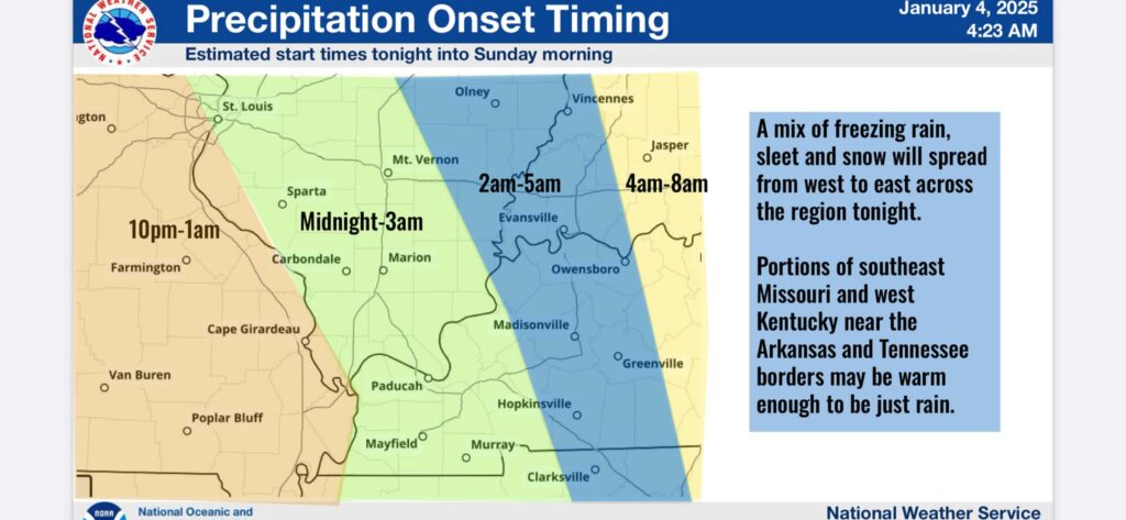
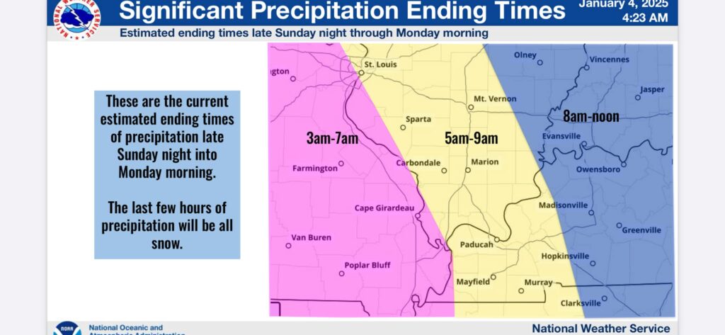
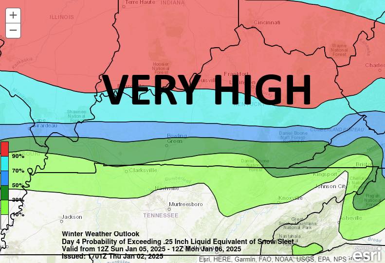
Here is the snow accumulation probabilities. Start times will be between 12-3 am Sunday for Calloway County. Ending times will be 5-9 am Monday. We will NOT have wintry precipitation for this entire duration.
A changeover to plain rain is expected for most of the Sunday pm hours. Travel problems and slick surfaces will be likely during Sunday and Monday mornings. The northern part of the county will see the most ice and most impacts. The southern part of the county will see the least ice and least impacts. Places along the Ohio River will have a substantial ice storm with tree damage and power outages. I am not expecting that in Calloway County at this time. The system will end with some light snow on Monday morning.
Remember, this is an evolving system so additional changes are possible. Monitor future updates.
UPDATE: 4 p.m. (1/3/25)
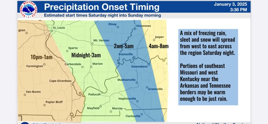
Here are the estimated start and end times for the wintry precipitation. Start times will be between 12-3 am Sunday for Calloway County. Ending times will be 5-9 am Monday. We will NOT have wintry precipitation for this entire duration. A changeover to plain rain is expected for most of the Sunday pm hours.
Travel problems and slick surfaces will be likely during Sunday and Monday mornings. The northern part of the county will see the most ice and most impacts. The southern part of the county will see the least ice and least impacts. Places along the Ohio River will have a substantial ice storm with tree damage and power outages. I am not expecting that in Calloway County at this time.
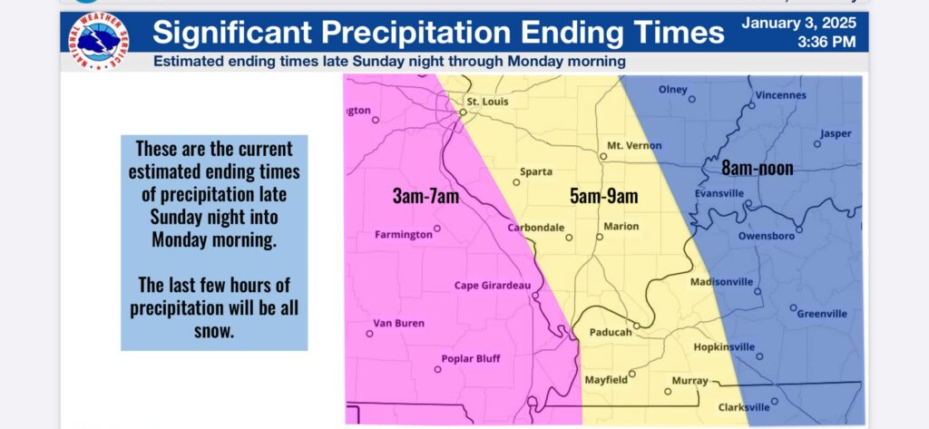
The system will end with some light snow on Monday morning. Remember, this is an evolving system so additional changes are possible. Monitor future updates.
UPDATE: 12 p.m. (1/3/25)

A powerful storm system is expected Sunday! Remember, this is an evolving storm system so some changes to the forecast are still possible. The track of the low pressure 30-40 miles north or south will make a world of difference in what your location sees.
Confidence continues to grow that parts of the Ohio Valley region will see travel impacts from a powerful winter storm that will affect parts of the region Sunday through Monday. The latest guidance is coming in a little colder than previous runs. The overall trend has been towards a surface low that will develop over the southern Rocky Mountains and pass near the Lower Ohio River and Upper Tennessee River Valleys.
The devil is always in the details with these types of events. A degree or two difference 2000 ft above the ground will have profound impacts on precipitation types and associated impacts.
The path of the surface low implies that there will be a warm nose layer of above-freezing air present during the heaviest precipitation Sunday afternoon for Calloway County. Overall, there looks to be a gradient of increasing impacts as you travel from south to north. Since this system will be laden with moisture from the Gulf of Mexico, whatever precipitation type a location gets, they will get a lot of it. Overall liquid QPF remains quite high, around 1.25-1.75″ in most areas.
As things stand now, we can make a “first guess” of precipitation types and potential impacts for Calloway County.
It appears that an initial burst of sleet or freezing rain is possible early on Sunday morning that could cause some slick travel on roads and other surfaces. As the day progresses temps should slowly warm above freezing changing the precipitation over to mainly liquid rain during the afternoon hours Sunday and Sunday night. However, as colder air filters into the region, the event will likely end as a light wintry mix or light snow late Sunday night or Monday morning. Overall, travel impacts here are possible at the beginning and ending of the event, but may be more spotty and intermittent given the potential for several hours of plain rain.
Areas to the north of the Ohio River will stand the best opportunity to see major ice and snow accumulations from this system. Anyone traveling north should be prepared for major road issues and even power outages.
It is not out of the realm of possibility to have a stray strong to severe storm Sunday afternoon since we should be south of the warm front.
The bottom line for the entire region: This forecast will likely shift and change over the next few days before things come in better focus by the weekend. Keep up to date on the latest forecast updates, and consider changing travel plans for Sunday-Monday if you can.
After this storm departs, a wave of very cold Arctic air will impact the region for much of the upcoming week. Right now, temperatures look to be about 10-20 degrees below normal, which would yield high temperatures in the 20s and lows in the single digits or teens. Subzero wind chill values are also a possibility. This wave of cold air looks to persist for several days, so groups that work with vulnerable populations should prepare for cold weather impacts to these groups. While overall, it looks pretty dry, all it would take would be a weak clipper system with 0.1-0.2″ of QPF to cause impactful snow events to occur. That will be something to watch after we get past the early week winter storm.
Stay with Murray/Calloway County Weather for all your local weather coverage!
UPDATE: 7:51 p.m. (1/2/25)
Highest risk for significant wintry precipitation is well north of Calloway County. Our time frame for concern for minor issues will be 1-10 am Sunday and again 1-10 am Monday.
UPDATE: 2:26 p.m. (1/2/25)
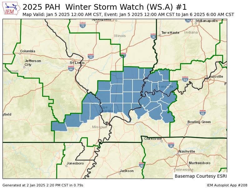
Winter storm watches being issued to our north for Sunday. This is as expected as the heavier ice accumulation will be north of Calloway County although we could still have some minor issues early Sunday morning and early Monday morning.
Original story (published Jan. 2)
MURRAY – Confidence continues to grow that parts of the Ohio Valley region will see travel impacts from a powerful winter storm that will affect parts of the region Sunday through Monday. The latest guidance has tipped its hand a bit on what the region will see.
The overall trend has been towards a surface low that will develop over the southern Rocky Mountains and pass near the Lower Ohio River and Upper Tennessee River Valleys. This has resulted in thermal profiles less supportive of an all-snow or even an all-ice event and more supportive of a mainly rain event.
The devil is always in the details with these types of events. A degree or two difference 2000 ft above the ground will have profound impacts on precipitation types and associated impacts.
The path of the surface low implies that there will be a warm nose layer of above-freezing air present during the heaviest precipitation Sunday afternoon and Sunday night. Overall, there looks to be a gradient of increasing impacts as you travel from south to north. Since this system will be laden with moisture from the Gulf of Mexico, whatever precipitation type a location gets, they will get a lot of it. Overall liquid QPF (Quantitative Precipitation Forecast) remains quite high, around 1.25-1.75″ in most areas.
As things stand now, we can make a “first guess” of precipitation types and potential impacts for Calloway County.
It appears that after an initial burst of sleet or freezing rain on Sunday morning, a change over to mainly liquid rain will happen during the afternoon hours Sunday and Sunday night. However, as colder air filters into the region, the event will likely end as a light wintry mix or light snow late Sunday night or Monday morning. Overall, travel impacts here are possible at the beginning and ending of the event but may be more spotty and intermittent given the potential for several hours of plain rain.
Areas to the north of the Ohio River will stand the best opportunity to see major ice and snow accumulations from this system. Anyone traveling north should be prepared for major road issues and even power outages.
The bottom line for the entire region: This forecast will likely shift and change over the next few days before things come in better focus by the weekend. Keep up to date on the latest forecast updates and consider changing travel plans for Sunday-Monday if you can.
After this storm departs, a wave of very cold Arctic air will impact the region for much of the upcoming week. Right now, temperatures look to be about 10-20 degrees below normal, which would yield high temperatures in the 20s and lows in the single digits or teens. Subzero wind chill values are also a possibility. This wave of cold air looks to persist for several days, so groups that work with vulnerable populations should prepare for cold weather impacts to these groups. While overall, it looks pretty dry, all it would take would be a weak clipper system with 0.1-0.2″ of QPF to cause impactful snow events to occur. That will be something to watch after we get past the early week winter storm.
Stay with Murray/Calloway County Weather for all your local weather coverage!
Scroll down for updates.
Justin Holland is the Official Weather Observer of Calloway County for the Paducah National Weather Service and the creator of the Facebook page Murray/Calloway County Weather, a hyper-local weather page followed by more than 17,000 people, and the website murrayweather.com. Holland also offers a severe weather alert texting service for $1/month. To sign up, email him at murraycallowaycountyweather17@yahoo.com.
RELATED COVERAGE: